
Super Storm: Hope for the best, prepare for the worst, officials advise
NORWICH – While it remains unknown exactly where Hurricane Sandy will make landfall, city and county officials are advising residents to keep an eye on the Category 1 storm over the weekend and to prepare for what some are calling a potential “super storm.”
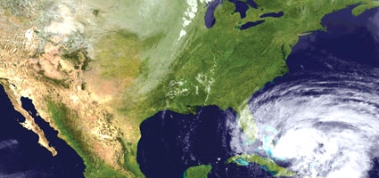
Sandy is currently making its way up the east coast and could contact the mainland anywhere from northern North Carolina to southern New England, according to the National Hurricane Center. The center’s website, nhc.noaa.gov, reports maximum sustained winds of 80 miles per hour as of this morning, while the City of Norwich Emergency Management Office reported the possibility of three to four inches of rain – depending on Sandy’s course – expected to fall here between Sunday and Tuesday.
“Flash flood guidance shows anything more than 2.6 inches of rain in a twelve-hour period would be enough to trigger flash flooding on small creaks and streams,” reported Norwich Emergency Management Officer A. Wesley Jones, who admitted “this is possible, but far from a certainty.”
Jones added that more rain would be needed to trigger flooding on larger waterways such as the Canasawacta Creek or the Chenango, Unadilla or Susquehanna rivers.


Comments