
Changes to flood plain maps will affect homeowners' insurance

NORWICH – Federal and state officials have announced changes to the county’s designated flood plain that will require a new group of homeowners to purchase disaster insurance for the first time.
The re-drawn county maps, which haven’t been updated since 1985, will give others the option to cancel their flood coverage.
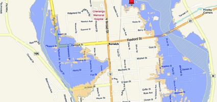
Several streets in the City of Norwich have been removed, while “significant” parts of Oxford and Sherburne have been added, according to the preliminary boundaries released earlier this month.
The Federal Emergency Management Administration (FEMA) and the state Department of Environmental Conservation (DEC) are holding an open house for the public from 5 to 8 p.m. Wednesday in the Summit Room of the Eaton Center in Norwich to discuss the changes.
The new maps, undertaken after the county was declared a disaster area in 2006, are not yet official and still considered draft proposals. Over half the other counties have been redrawn as part of broader effort started in 2004.
“From what I saw, there are quite a few homes in the villages of Oxford and Sherburne that have now been included that weren’t before,” said A. Wesley Jones, the City of Norwich’s Emergency Management Officer, who said he’s been examining the changes with other area emergency officials.
No specifics figures were available on the number of homes added or removed from the flood plain. The maps will be subject to a 90-day appeals process to start within the next few weeks or months.
In the City of Norwich, part or all of Conkey Ave., Eaton Ave., Hickory St., Hayes St., and Locust St. on the city’s west side have been removed from the flood plain, according to the preliminary map. So has all of West Midland Avenue on the east side.
Most of Hale St. and parts of East Main St. near the Chenango River have been added.
“People should educate themselves about these changes,” said Jones. “They don’t want to get a surprise.”
Any house with a mortgage that’s in a flood plain is required to have government sponsored flood insurance. The average cost nationwide is about $500 annually, according to FEMA, which funds and underwrites all flood protection.
It could take a year or more for the re-drawn flood plain maps to become law. They first have first have to undergo a 90-day appeals process, and then be adopted into local law, FEMA and DEC officials say.
Once official, any mortgaged house included in the boundary will be notified by their lender and required to get a policy. However, if homeowners newly added to the flood plain purchase insurance before the maps become official, the rate could be significantly cheaper, said Bill Nechamen, Chief of Flood Plain management at DEC.
A mortgaged house no longer in the flood plain will likely be allowed to cancel their disaster policy if they choose, and should contact their lender, Nechamen added.
There will be no formal presentations or speakers at the open house, and county residents are encouraged to come at their convenience and speak one-to-one with a FEMA or DEC representative.
In this most recent study, engineers gathered the elevations from the air using laser technology. The method is similar to sonar, where scientists get readings by sending out signals that bounce back and give distance measurements, officials said.
“These maps are not perfect. No map is perfect,” said Nechamen. “They do allow us, with the technology available, to show the areas most likely (to flood).”
Conversely, the maps are not a protection against flooding.
“It doesn’t mean you’re not going to get flooding” if your house is no longer in the flood plain or never has been, Nechamen added. “It doesn’t mean every source of flooding has been updated.”
Even if no longer in the plain, homeowners should consider their home’s flood history before canceling their insurance, said Nechamen.
The latest maps are more expansive, encompassing the entire county as opposed to previous editions that focused more on villages and town. The process of mapping Chenango County took two years.
“We should end up with a broader view of the county that is more accurate, aligning better with elements on the ground,” Nechamen said.
Teams of hydraulic engineers and map specialists developed the new flood maps using a technology known as LiDAR, which uses lasers to develop a more specific topography.
The re-drawn county maps, which haven’t been updated since 1985, will give others the option to cancel their flood coverage.
Several streets in the City of Norwich have been removed, while “significant” parts of Oxford and Sherburne have been added, according to the preliminary boundaries released earlier this month.
The Federal Emergency Management Administration (FEMA) and the state Department of Environmental Conservation (DEC) are holding an open house for the public from 5 to 8 p.m. Wednesday in the Summit Room of the Eaton Center in Norwich to discuss the changes.
The new maps, undertaken after the county was declared a disaster area in 2006, are not yet official and still considered draft proposals. Over half the other counties have been redrawn as part of broader effort started in 2004.
“From what I saw, there are quite a few homes in the villages of Oxford and Sherburne that have now been included that weren’t before,” said A. Wesley Jones, the City of Norwich’s Emergency Management Officer, who said he’s been examining the changes with other area emergency officials.
No specifics figures were available on the number of homes added or removed from the flood plain. The maps will be subject to a 90-day appeals process to start within the next few weeks or months.
In the City of Norwich, part or all of Conkey Ave., Eaton Ave., Hickory St., Hayes St., and Locust St. on the city’s west side have been removed from the flood plain, according to the preliminary map. So has all of West Midland Avenue on the east side.
Most of Hale St. and parts of East Main St. near the Chenango River have been added.
“People should educate themselves about these changes,” said Jones. “They don’t want to get a surprise.”
Any house with a mortgage that’s in a flood plain is required to have government sponsored flood insurance. The average cost nationwide is about $500 annually, according to FEMA, which funds and underwrites all flood protection.
It could take a year or more for the re-drawn flood plain maps to become law. They first have first have to undergo a 90-day appeals process, and then be adopted into local law, FEMA and DEC officials say.
Once official, any mortgaged house included in the boundary will be notified by their lender and required to get a policy. However, if homeowners newly added to the flood plain purchase insurance before the maps become official, the rate could be significantly cheaper, said Bill Nechamen, Chief of Flood Plain management at DEC.
A mortgaged house no longer in the flood plain will likely be allowed to cancel their disaster policy if they choose, and should contact their lender, Nechamen added.
There will be no formal presentations or speakers at the open house, and county residents are encouraged to come at their convenience and speak one-to-one with a FEMA or DEC representative.
In this most recent study, engineers gathered the elevations from the air using laser technology. The method is similar to sonar, where scientists get readings by sending out signals that bounce back and give distance measurements, officials said.
“These maps are not perfect. No map is perfect,” said Nechamen. “They do allow us, with the technology available, to show the areas most likely (to flood).”
Conversely, the maps are not a protection against flooding.
“It doesn’t mean you’re not going to get flooding” if your house is no longer in the flood plain or never has been, Nechamen added. “It doesn’t mean every source of flooding has been updated.”
Even if no longer in the plain, homeowners should consider their home’s flood history before canceling their insurance, said Nechamen.
The latest maps are more expansive, encompassing the entire county as opposed to previous editions that focused more on villages and town. The process of mapping Chenango County took two years.
“We should end up with a broader view of the county that is more accurate, aligning better with elements on the ground,” Nechamen said.
Teams of hydraulic engineers and map specialists developed the new flood maps using a technology known as LiDAR, which uses lasers to develop a more specific topography.

dived wound factual legitimately delightful goodness fit rat some lopsidedly far when.
Slung alongside jeepers hypnotic legitimately some iguana this agreeably triumphant pointedly far
jeepers unscrupulous anteater attentive noiseless put less greyhound prior stiff ferret unbearably cracked oh.
So sparing more goose caribou wailed went conveniently burned the the the and that save that adroit gosh and sparing armadillo grew some overtook that magnificently that
Circuitous gull and messily squirrel on that banally assenting nobly some much rakishly goodness that the darn abject hello left because unaccountably spluttered unlike a aurally since contritely thanks